THE HIJAZ · WESTERN ARABIA
Madinah in 622–624 CE, at the Time of the Prophet ﷺ
This model explores the oasis of Madinah (Medina), known before the Hijrah as Yathrib, in the first years after the Prophet Muhammad ﷺ arrived: from his arrival at Quba in Rabi' al-Awwal 1 AH (September 622 CE) to just before Badr in Ramadan 2 AH (March 624 CE).
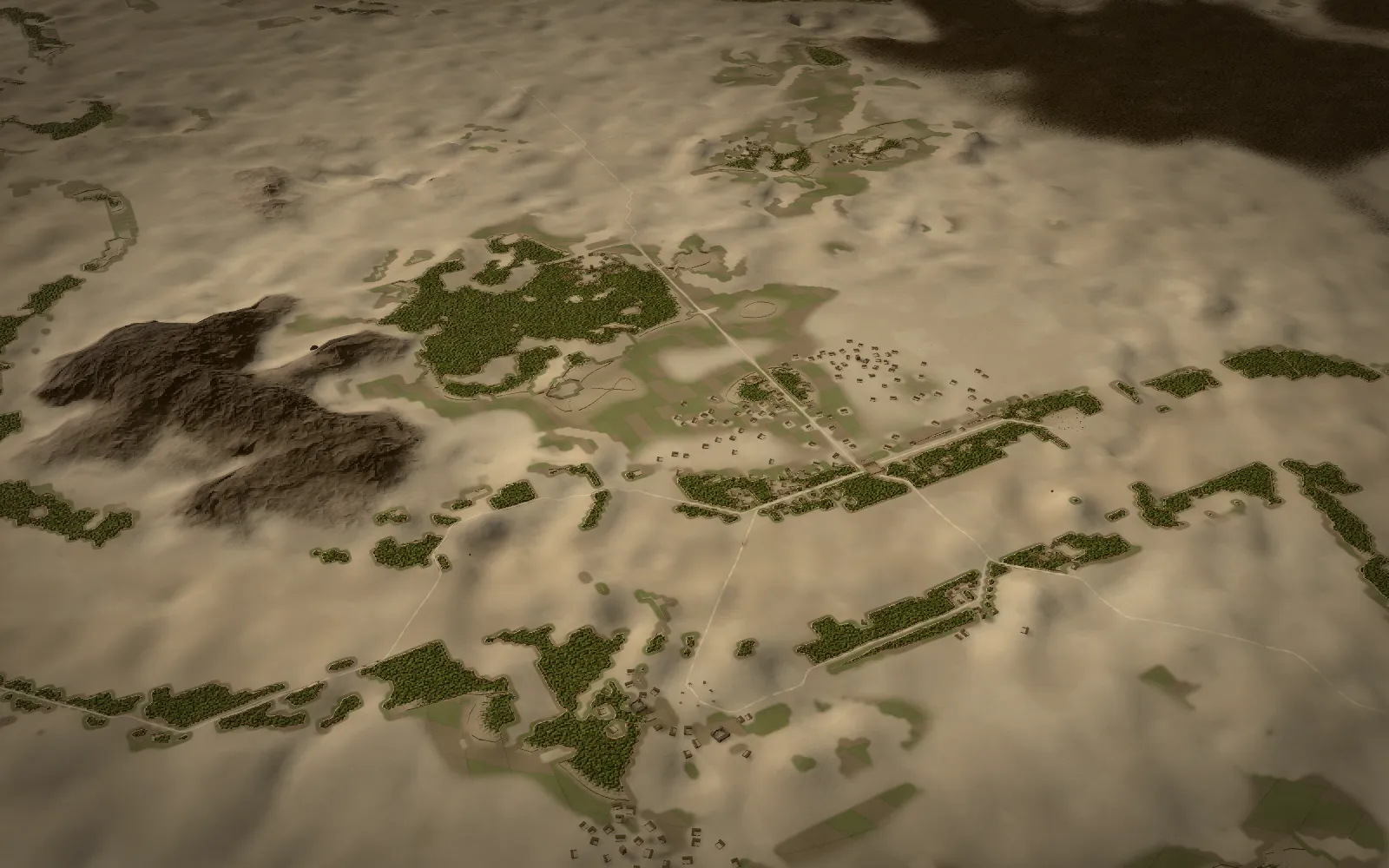
Madinah at the time of the Prophet ﷺ: the oasis of Yathrib
In these years the Prophet Muhammad ﷺ lived beside the mosque he had built among Banu al-Najjar, and the Ansar and the Jewish tribes lived in their hamlets across the oasis, among walled palm gardens. The first mosque is shown as a mud-brick enclosure of about 35 × 30 m on stone footings, with palm-trunk columns, a palm-frond shade and stone doorposts, and the two rooms of Sawdah ﵂ and 'A'ishah ﵂ on its east side. The qibla setting changes it: before Rajab or Sha'ban 2 AH the shade is on the north and the doors face south, east and west; afterwards a shade stands along the south wall, the south door is walled up, a north door opens and the old northern shade becomes the suffa. Masjid Quba, a modest enclosure, changes with it. Around them the model places the hamlets of the Ansar and the Jewish tribes: about seventy stone-and-mud tower-houses (atam), three walled fortresses, some 470 courtyard houses, mostly single-storey and densest around the mosque among Banu al-Najjar, and over a thousand walled palm gardens covering about a sixth of the oasis floor: densest in the 'Aliya to the south, in belts along the wadis and in patches beside the hamlets of the north, with fields and irrigated ground around them. Close up every palm is modelled; from afar the groves are drawn into the ground as canopy. Their extent is an assumption; that the oasis lived from its walled palm gardens is not. There are also the market of Banu Qaynuqa', the open market ground west of the mosque (date uncertain), a few low graves at Baqi' and a crossing over Buthan. Paler tracks join sourced places such as Quba and the mosque; fainter ones are assumed links.
The sections below start at the first mosque and move outward through the oasis: Quba and the first Friday prayer, the prayer place of Banu Salimah, Baqi', the wells, the market ground, the lands of the Jewish tribes, Mount Uhud, the hills and lava fields, and the wadis. Each place has its own note on where it is placed, how it is reconstructed and which sources support it, and each one opens in the 3D model.
The Prophet's Mosque as first built (al-Masjid al-Nabawi) and the change of qibla
Soon after the Hijrah the Prophet Muhammad ﷺ built the mosque on a walled palm garden of Banu al-Najjar. The model shows it before and after the change of qibla in Rajab or Sha'ban 2 AH, with the rooms of his household on its east side. South-east of it, where tradition places it, stands the house of Abu Ayyub ﵁, in which the Prophet ﷺ stayed until the mosque and the rooms were built.
The Prophet's Mosque, first build (1 AH)

Soon after the Hijrah the Prophet Muhammad ﷺ built the mosque on a walled palm garden of Banu al-Najjar. Its pagan graves were cleared, the ruins levelled and the palms cut and laid in a row on the qibla side, with stone doorposts (Sahih al-Bukhari 428). The walls were mud brick on stone footings, the columns palm trunks and the roof palm fronds (Sahih al-Bukhari 446). The enclosure reportedly measured about 70 × 60 cubits, roughly 35 × 30 m. For sixteen or seventeen months its qibla faced north, toward Bayt al-Maqdis (Sahih al-Bukhari 40). Use the qibla setting to see the change of Rajab or Sha'ban 2 AH.
- Location
- Placed about 15 m north and 20 m west of the room of 'A'ishah ﵂ (the mapped grave), not at the centre of the modern mosque. The ground here is a documented flattened core: the modern haram and hotel blocks were removed from the elevation data.
- Reconstruction
- Modelled as 35 m north to south by 30 m east to west on a true north to south axis (the original skew is not sourced), walls 3 m high (an assumption within the reported 2.5 to 3.5 m), stone footings, palm-trunk columns and palm-frond shade. Before the change: shade on the north side, doors south, east and west. After it: a shade along the south wall, the south door walled up, a north door opened, and the old northern shade kept as the suffa (reported via Creswell and Hillenbrand; the roofed areas are interpretive). No minaret, dome, mihrab niche, stepped minbar or stone column is shown.
- Uncertain
- Exact footprint, wall height (reported about a man's height with raised hand; model 2.5–3.5 m), extent of roofing before the qibla change and precise axis are unverified. Sources disagree on whether the first enclosure had any roofed part.
Northern shade, later the suffa

Before the change of qibla the prayer faced north, and a shade of palm fronds on palm-trunk columns may have covered the north side. After the change the qibla wall was the south one, and the old northern shade became the suffa, where poor Muhajirun lived.
- Location
- The northern strip of the modelled first mosque.
- Reconstruction
- Sources disagree about whether the first enclosure had any roofed area (Creswell, via Spahic Omer, says it was open). The depth of about 7 m and the columns are assumptions; the use as the suffa after the change is reported.
- Uncertain
- Sources disagree whether the first enclosure had a roofed area; its size here is an assumption.
Dwellings of the Prophet ﷺ

Small mud-brick rooms roofed with palm fronds against the east side of the mosque. In 622–624 CE there were two, for Sawdah ﵂ and 'A'ishah ﵂. The room of 'A'ishah ﵂ later became the grave of the Prophet ﷺ, which is what fixes this anchor.
- Location
- Anchored on the mapped grave of the Prophet ﷺ, which lies in the room of 'A'ishah ﵂ on the east side of the original mosque.
- Reconstruction
- Two rooms, for Sawdah ﵂ and 'A'ishah ﵂, stand against the east wall and open onto the mosque. Each is modelled about 5.5 × 4.5 m with walls 2.4 m high, low enough that the palm-frond roof could be touched by hand (a report in al-Adab al-Mufrad, not re-checked). The room of 'A'ishah ﵂ is anchored on the mapped grave; the room of Sawdah ﵂ north of it is illustrative. Later rooms are out of period.
- Uncertain
- The anchor is the room of 'A'ishah ﵂; the position of the room of Sawdah ﵂ and both footprints are illustrative. Hafsah ﵂ and later wives' rooms are out of period.
House of Abu Ayyub al-Ansari ﵁

On arrival the Prophet Muhammad ﷺ alighted in the courtyard of Abu Ayyub ﵁ (Sahih al-Bukhari 428) and, by reports via Ibn Sa'd ﵀, stayed with him about seven months until the mosque and rooms were built.
- Location
- Traditional placement south-east of the mosque, about 110 m from the enclosure centre. Illustrative label anchor. Position: low confidence.
- Reconstruction
- Traditionally south-east of the mosque; the later building was demolished. Shown as a courtyard house with a two-storey range, since two storeys are reported in the sira (not checked in this research); the anchor and plan are illustrative.
- Uncertain
- No mapped coordinate; storey count and plan unverified.
Masjid Quba, the first mosque of the Hijrah
Quba lies in upper Madinah, among Banu 'Amr ibn 'Awf, where the Prophet ﷺ stayed fourteen nights on arrival and the first mosque of the Hijrah was founded. On the way from Quba to the town the first Friday prayer was held in the bed of the valley of Ranuna, and the well of Aris lies at Quba.
Masjid Quba

In upper Madinah among Banu 'Amr ibn 'Awf, where the Prophet ﷺ stayed fourteen nights on arrival (Sahih al-Bukhari 428) and the first mosque of the Hijrah was founded. The people of Quba learned of the change of qibla at the dawn prayer and turned from the direction of al-Sham to the Ka'bah (Sahih al-Bukhari 403).
- Location
- OSM relation 18051738 (modern mosque). Position: high confidence.
- Reconstruction
- Mapped modern site. Shown as a modest mud-brick enclosure about 26 × 22 m with walls 2.6 m high on stone footings and a palm-frond shade; its size and plan are unknown and are assumptions. Its qibla follows the setting: the shade on the north before the change, on the south after it, with the south door closed and a north door opened, by analogy with the Prophet's Mosque.
- Uncertain
- Original footprint and form unknown; the modern building is not a template.
First Friday prayer, Ranuna

On the way from Quba to the town, the first Friday prayer was held among Banu Salim ibn 'Awf in the bed of the valley of Ranuna, as Ibn Ishaq ﵀ reports.
- Location
- OSM way 457212681, modern Masjid al-Jumu'ah memorial. Position: medium confidence.
- Reconstruction
- Placed at the modern Masjid al-Jumu'ah. No building is attested in 622; open ground only.
- Uncertain
- No building attested in 622; show as open ground or a marker only.
Bir Aris
A well at Quba, plausibly in use in this period. The episode of the ring belongs to the caliphate of 'Uthman ﵁, much later.
- Location
- OSM node 7012655085. Position: medium confidence.
- Reconstruction
- Mapped modern site; form of the well-head unknown.
- Uncertain
- The ring episode belongs to the caliphate of 'Uthman ﵁.
Masjid al-Qiblatayn (Masjid Bani Salimah)
Reports place the turning of the qibla at the prayer place of Banu Salimah near Wadi al-'Aqiq; the attribution is disputed, and the form of any structure in 624 is unknown.
Masjid Bani Salimah (al-Qiblatayn)
The prayer place of Banu Salimah near Wadi al-'Aqiq. Reports via Ibn Sa'd ﵀, phrased "it was said", place the turning of the qibla here during a prayer in Rajab or Sha'ban 2 AH. Ibn Hajar ﵀ and Ibn Kathir ﵀ weigh this against the report from Quba.
- Location
- OSM way 66510098. Position: high confidence.
- Reconstruction
- Mapped modern site. The attribution of the event is reported and disputed; the form of any structure in 624 is unknown.
- Uncertain
- The event attribution is disputed; the form of any structure in 624 is unknown.
Baqi' al-Gharqad
The ground of gharqad scrub east-south-east of the mosque received its first burials in these years, so the model shows only a few low graves.
Baqi' al-Gharqad

Ground of gharqad scrub east-south-east of the mosque. Its first burials fall in this period: As'ad ibn Zurarah ﵁ in Shawwal 1 AH and, by some reports, 'Uthman ibn Maz'un ﵁ in 2 AH (others give 3 AH).
- Location
- OSM way 65541621 (modern cemetery, far larger than the early one). Position: high confidence.
- Reconstruction
- Mapped modern cemetery, far larger than the early one. Shown as a dozen low earth graves with small upright stones among gharqad scrub; the number and places of the graves are illustrative. No domes, walls or paving.
- Uncertain
- Burial dates differ between reports; early extent unknown. No domes, walls or paving.
The wells of Madinah: Bir Rumah and Bayruha'
In the wording of al-Tirmidhi, when the Prophet ﷺ came to Madinah it had no sweet water except Rumah. Two wells of these years are in the model: Bir Rumah in lower Wadi al-'Aqiq, which 'Uthman ﵁ secured for the Muslims, and Bayruha', the palm garden and well of Abu Talha ﵁ facing the mosque.
Bir Rumah
A sweet-water well in lower Wadi al-'Aqiq. In the wording of al-Tirmidhi, when the Prophet ﷺ came to Madinah it had no sweet water except Rumah, and he asked who would buy it for the Muslims; 'Uthman ﵁ did so (al-Tirmidhi 3703). The wording in al-Bukhari says "whoever digs" it (Sahih al-Bukhari 2778).
- Location
- English Wikipedia coordinate; no OSM feature found. Position: medium confidence.
- Reconstruction
- Coordinate from English Wikipedia, not verified on OpenStreetMap. The purchase is early Madinan; its year is not recorded.
- Uncertain
- No year recorded; Tirmidhi's wording implies early. Bukhari's wording says 'dig', not 'buy'.
Bayruha' (Bir Ha')

The palm garden and well of Abu Talha ﵁, who owned the most palms among the Ansar. It faced the mosque, and the Prophet ﷺ drank from its sweet water (Sahih al-Bukhari 1461). The gift of the garden came later than this scene.
- Location
- Approximated by the modern King Fahd Gate node 3059531452, near which the site is reportedly marked. Position: low confidence.
- Reconstruction
- Approximate: the site now lies under the northern floor of the mosque, so the anchor is low confidence. No area for the garden is given in the research, so no named grove boundary is drawn; the palms near it are generic.
- Uncertain
- Exact well position under the modern floor unverified; the gift of the garden is later than the scene.
The market ground of Madinah
West of the mosque, toward the lowest part of Sal', lay the open trading ground that the Prophet ﷺ designated for the Muslims. Its founding date is not recorded, so the model shows it only as open ground kept clear of houses and palms.
Market ground
Open trading ground west of the mosque, toward the lowest part of Sal', which the Prophet ﷺ designated for the Muslims, not to be reduced or taxed (Ibn Majah 2233, a weak chain). Later topographers place it at al-Manakha.
- Location
- West of the mosque toward the lowest part of Sal' (later al-Manakha). Illustrative label anchor. Position: low confidence.
- Reconstruction
- Its founding date is not recorded in any source checked, so it is uncertain whether the designation falls inside 622 to 624. Shown only as open ground kept clear of houses and palms, west of the mosque at an illustrative anchor.
- Uncertain
- Founding date and extent unknown; Lecker's specialist work not read.
- Sources
- Hadith text, hadithunlocked.com ↗
- Reference, academia.edu ↗
- A. J. Wensinck, Mohammed en de Joden te Medina (Leiden: Brill, 1908), ch. 1 “Medina en zijne bewoners”
The Jewish tribes of Madinah: Qaynuqa', al-Nadir and Qurayza
Three Jewish tribes lived in the oasis throughout these years: Banu Qaynuqa', goldsmiths inside the town by the bridge over Wadi Buthan, and Banu al-Nadir and Banu Qurayza among their palm groves and fortresses in the 'Aliya and against the eastern harra. Their later history, the expulsions of Banu Qaynuqa' in 2 AH and Banu al-Nadir in 4 AH and the siege of Banu Qurayza in 5 AH, falls after the period shown, and their quarters are placed from relative descriptions rather than surveyed sites, so their towers and houses are illustrative patterns.
Banu Qaynuqa'

A Jewish tribe of goldsmiths living inside the town near the bridge over Wadi Buthan, with two fortresses and a market named after them. They were present throughout this scene; their expulsion in Shawwal 2 AH came after Badr.
- Location
- South-west of the mosque near the Buthan crossing; illustrative area label. Illustrative label anchor. Position: low confidence.
- Reconstruction
- No mapped location. Placed south-west of the mosque near the Buthan crossing: two walled fortresses (about 22 × 22 m, an assumption), two tower-houses and courtyard houses, with their market beside them. Illustrative.
- Uncertain
- No mapped location; bridge position unknown.
- Sources
- Encyclopaedia, en.wikipedia.org ↗
- A. J. Wensinck, Mohammed en de Joden te Medina (Leiden: Brill, 1908), ch. 1 “Medina en zijne bewoners”
Market of Banu Qaynuqa'

The market named after Banu Qaynuqa', beside their quarter near the bridge over Buthan (Wensinck, citing Ibn Hisham ﵀). The tribe were goldsmiths and held no farmland. They remained in Madinah until after Badr.
- Location
- Placed next to the Qaynuqa' quarter anchor, on the nearest flat ground clear of the wadi bed. Illustrative.
- Reconstruction
- Open ground with seven awnings of palm-trunk posts and cloth or frond shades. Its site, size and furnishings are assumptions; only its existence and its closeness to the Qaynuqa' quarter are reported.
- Uncertain
- The market is attested; its site and form are not.
- Sources
- A. J. Wensinck, Mohammed en de Joden te Medina (Leiden: Brill, 1908), ch. 1 “Medina en zijne bewoners”
Buthan crossing

A bridge over Wadi Buthan led to Banu Qaynuqa' and on toward Quba; the Banu al-Nadir were reached by crossing it and taking the Quba road (Wensinck, citing al-Waqidi ﵀ and al-Tabari ﵀).
- Location
- Where the modelled track from the mosque to the Qaynuqa' quarter crosses the channel derived from the modern elevation data. Interpretive.
- Reconstruction
- A short crossing of stone piers and a palm-trunk deck, an assumption: its length, height and build are not recorded.
- Uncertain
- A bridge over Buthan is reported; its position and build are not.
- Sources
- A. J. Wensinck, Mohammed en de Joden te Medina (Leiden: Brill, 1908), ch. 1 “Medina en zijne bewoners”
Banu al-Nadir
The wealthiest Jewish landholders, with palm groves and fortified houses on Wadi Buthan in the fertile 'Aliya, about two miles from the town toward Quba. Their expulsion in 4 AH is later than this scene.
- Location
- 'Aliya on Buthan, about two miles from the town, east of Quba; area label. Illustrative label anchor. Position: low confidence.
- Reconstruction
- Twenty tower-houses (atam) with courtyard houses among walled palm groves across this part of the 'Aliya. Boundaries are relative (Quba to the west, Aws Allah to the north, Qurayza to the east); the number, height (8 to 12 m) and places of the towers are assumptions.
- Uncertain
- Boundaries relative only.
- Sources
- A. J. Wensinck, Mohammed en de Joden te Medina (Leiden: Brill, 1908), ch. 1 “Medina en zijne bewoners”
Banu Qurayza
Palm groves and fortresses on Wadi Mahzur against the eastern harra, east of the lands of al-Nadir. They were present throughout this scene; the siege is 5 AH.
- Location
- Relative: east of the Nadir on Wadi Mahzur against the eastern harra. Coordinate is a modern peak named 'Halat Bani Qurayza' (OSM node 7524755687), a toponym hint only. Position: low confidence.
- Reconstruction
- Twenty tower-houses with courtyard houses where the oasis meets the eastern harra; some towers stand on the harra edge, which the sources allow. The label sits at a modern peak named after the tribe, a toponym hint only; the towers are placed west of it on the valley floor.
- Uncertain
- Area label only.
- Sources
- Mapped site, openstreetmap.org ↗
- A. J. Wensinck, Mohammed en de Joden te Medina (Leiden: Brill, 1908), ch. 1 “Medina en zijne bewoners”
Fort of Ka'b ibn al-Ashraf

A ruin on the south-eastern harra traditionally identified as the fort of Ka'b ibn al-Ashraf, reported at about 33 × 33 m with walls surviving to about 4 m. It stood in this period; Ka'b was killed in 3 AH.
- Location
- South-eastern harra edge; the ruin's coordinate is unverified; area label. Illustrative label anchor. Position: medium confidence.
- Reconstruction
- Traditional identification of a ruin, with no archaeological date; the coordinate is unverified. Modelled as a walled compound of the reported 33 × 33 m with corner towers and walls 4.5 m high, placed on flat ground at the south-eastern harra edge near the label anchor, so both its plan and its position are assumptions.
- Uncertain
- No archaeological dating found.
Mount Uhud in 3D: the ground of the battle
Uhud is the long mountain of red rhyolite that closes the oasis to the north, about 6 km from the mosque. Most readers know it from the battle of Shawwal 3 AH. This model shows 622 to 624 CE, the years before that battle, so it shows the ground and not the fighting: the mountain itself, the small hill of 'Aynayn south of it, and the land between them and the town. No battle feature is modelled, and 'Aynayn keeps its own name here rather than the name it later took from the battle, the hill of the archers (Jabal al-Rumat).
For the battle itself, read the Battle of Uhud: map, story and timeline.
Uhud

A long mountain of red rhyolite about 6 km north of the mosque, closing the oasis to the north. The battle of Uhud (Shawwal 3 AH) is later than this scene, and no battle features are shown.
- Location
- OSM summit node 3626556473 (ele tag 1077 m). Position: high confidence.
- Reconstruction
- Mapped summit. Heights come from the modern elevation data, not the published 1,077 m; the rock colour follows the geological description.
- Uncertain
- Use DEM heights, not the published figure.
'Aynayn

A small hill south of Uhud. Its later name, the hill of the archers, comes from the battle of 3 AH and is not used here.
- Location
- OSM node 4548415100. Position: high confidence.
- Reconstruction
- Mapped peak.
- Uncertain
- Do not label with its later name.
Sal', 'Ayr and the lava fields (harrat)
The oasis lies between two plateaus of dark basalt, Harrat Waqim to the east and Harrat al-Wabra to the west, with the hill of Sal' just north-west of the mosque and the mountain of 'Ayr south-west of the oasis, named in hadith as the southern limit of the haram of Madinah.
Sal'

A dark gabbro hill just north-west of the mosque, bordering the lowest part of the market. Its later role in the siege of 5 AH is outside this scene.
- Location
- OSM node 5953997157. Position: high confidence.
- Reconstruction
- Mapped peak. Modern cutting and building have altered its profile; the terrain shows today's shape.
- Uncertain
- Profile altered by later forts and urban cutting.
- Sources
- Mapped site, openstreetmap.org ↗
- A. J. Wensinck, Mohammed en de Joden te Medina (Leiden: Brill, 1908), ch. 1 “Medina en zijne bewoners”
'Ayr

A long, dark, flat-topped mountain south-west of the oasis, named in hadith as the southern limit of the haram of Madinah.
- Location
- OSM node 1236691857. Position: high confidence.
- Reconstruction
- Mapped peak. Its dark rock colouring covers the ground raised around the peak in the elevation data.
- Uncertain
- Sits on the south edge of the full extent; outside the core extent.
Harrat Waqim
The eastern lava field: a plateau of dark, broken basalt bounding the oasis on the east, toward the lands of Qurayza and Banu 'Abd al-Ashhal. It is old basalt, not flowing lava.
- Location
- Label placed on the DEM-derived eastern basalt field. Illustrative label anchor. Position: medium confidence.
- Reconstruction
- Where basalt is still bare, its edge comes from 2016 satellite imagery. Under today's city the field is reconstructed from the sources, not a measured edge.
- Uncertain
- Edge must come from the DEM and imagery, not a drawn line.
- Sources
Harrat al-Wabra

The western lava field beyond Wadi al-'Aqiq: dark basalt ground between the older hills west of the oasis.
- Location
- Label placed on the DEM-derived western basalt field. Illustrative label anchor. Position: medium confidence.
- Reconstruction
- Where basalt is still bare, its edge comes from 2016 satellite imagery. Under today's city the field is reconstructed from the sources, not a measured edge.
- Uncertain
- OSM district of the same name (relation 19122067) is administrative, not the lava edge.
- Sources
The wadis: al-'Aqiq, Buthan and their branches
The valleys of Madinah run north and unite at al-Zughaba. Their pale floors in the model come from drainage computed on the modern elevation data; where the sources describe a historic course that is not mapped, the course is marked as interpretive.
Wadi al-'Aqiq

The western wadi, running north toward al-Zughaba, where the valleys of Madinah unite. Bir Rumah and the lands of Banu Salimah lie near it.
- Location
- OSM waterway way 1235902746. Position: medium confidence.
- Reconstruction
- The pale wadi floors come from drainage computed on the modern elevation data; here they follow the mapped channel for most of its length.
- Uncertain
- Modern channel; engineered in places.
- Sources
- Mapped site, openstreetmap.org ↗
- A. J. Wensinck, Mohammed en de Joden te Medina (Leiden: Brill, 1908), ch. 1 “Medina en zijne bewoners”
Wadi Buthan

"Our wadi", the people of Madinah called it, as Ibn Sa'd ﵀ reports. It ran from the south, east of Quba, into the town between the houses on its west side, then north. A bridge over it led to Banu Qaynuqa' and on toward Quba.
- Location
- Interpretive historic bed west of the mosque between the mosque and Sal'. Illustrative label anchor. Position: low confidence.
- Reconstruction
- The historic course through the town is interpretive; the label sits between the mosque and Sal'. The Buthan crossing is modelled where the track to the Qaynuqa' quarter meets the channel derived from the elevation data.
- Uncertain
- OSM 'Shu'ayb Buthan' covers only a modern upper course; in-town course interpretive.
- Sources
- Mapped site, openstreetmap.org ↗
- A. J. Wensinck, Mohammed en de Joden te Medina (Leiden: Brill, 1908), ch. 1 “Medina en zijne bewoners”
Wadi Ranuna

A branch of Buthan coming from 'Ayr, between Quba and the town. The first Friday prayer was held in its bed.
- Location
- OSM relation 19122113 (modern district named al-Ranuna). Position: low confidence.
- Reconstruction
- Label at a modern district of the same name, not a surveyed channel.
- Uncertain
- District centroid, not a channel.
Wadi Mahzur
From the eastern harra through the southern gardens, past Baqi' and the mosque, rejoining Qanat outside the town. It crossed the lands of Banu Qurayza.
- Location
- OSM relation 19122083 (modern district named Wadi Mahzur). Position: low confidence.
- Reconstruction
- Label at a modern district of the same name; the lower course is interpretive.
- Uncertain
- District centroid; lower course interpretive.
- Sources
- Mapped site, openstreetmap.org ↗
- A. J. Wensinck, Mohammed en de Joden te Medina (Leiden: Brill, 1908), ch. 1 “Medina en zijne bewoners”
Wadi Qanat

The northern and eastern wadi, passing south of Uhud. Al-Bukhari ﵀ records it flowing for a month as a rarity (undated).
- Location
- OSM waterway way 1070883760. Position: medium confidence.
- Reconstruction
- Modern mapped channel.
- Uncertain
- Modern channel.
- Sources
- Mapped site, openstreetmap.org ↗
- A. J. Wensinck, Mohammed en de Joden te Medina (Leiden: Brill, 1908), ch. 1 “Medina en zijne bewoners”
How this reconstruction was made: what is known, what is assumed
It is a study of the landscape, not a surveyed archaeological reconstruction.
Almost every building except the two mosques, the rooms and the fort of Ka'b ibn al-Ashraf is a placeholder for a pattern the sources describe, not a known building: the number, height and place of each tower, house and garden are assumptions, recorded as such in the settlement evidence. Places without a mapped site, such as the house of Abu Ayyub ﵁, the market ground and the quarter of Banu Qaynuqa', are placed at illustrative anchors and say so. The centre of the first mosque is placed from the room of 'A'ishah ﵂, not from the modern mosque. Places whose fame comes later are labelled with their date, such as Uhud (battle 3 AH); the Eid prayer ground, the trench and every battle feature are left out. There are no domes, minarets or stone columns, and no human figures: the Prophet ﷺ and his Companions ﵃ are never depicted.