THE HIJAZ · WESTERN ARABIA
Makkah in 610–615 CE, at the Time of the Prophet ﷺ
This model explores how the sanctuary and early settlement sit within the connected valleys and rocky ridges of Makkah (Mecca). It depicts an interpretation of the early revelation period, around 610–615 CE.
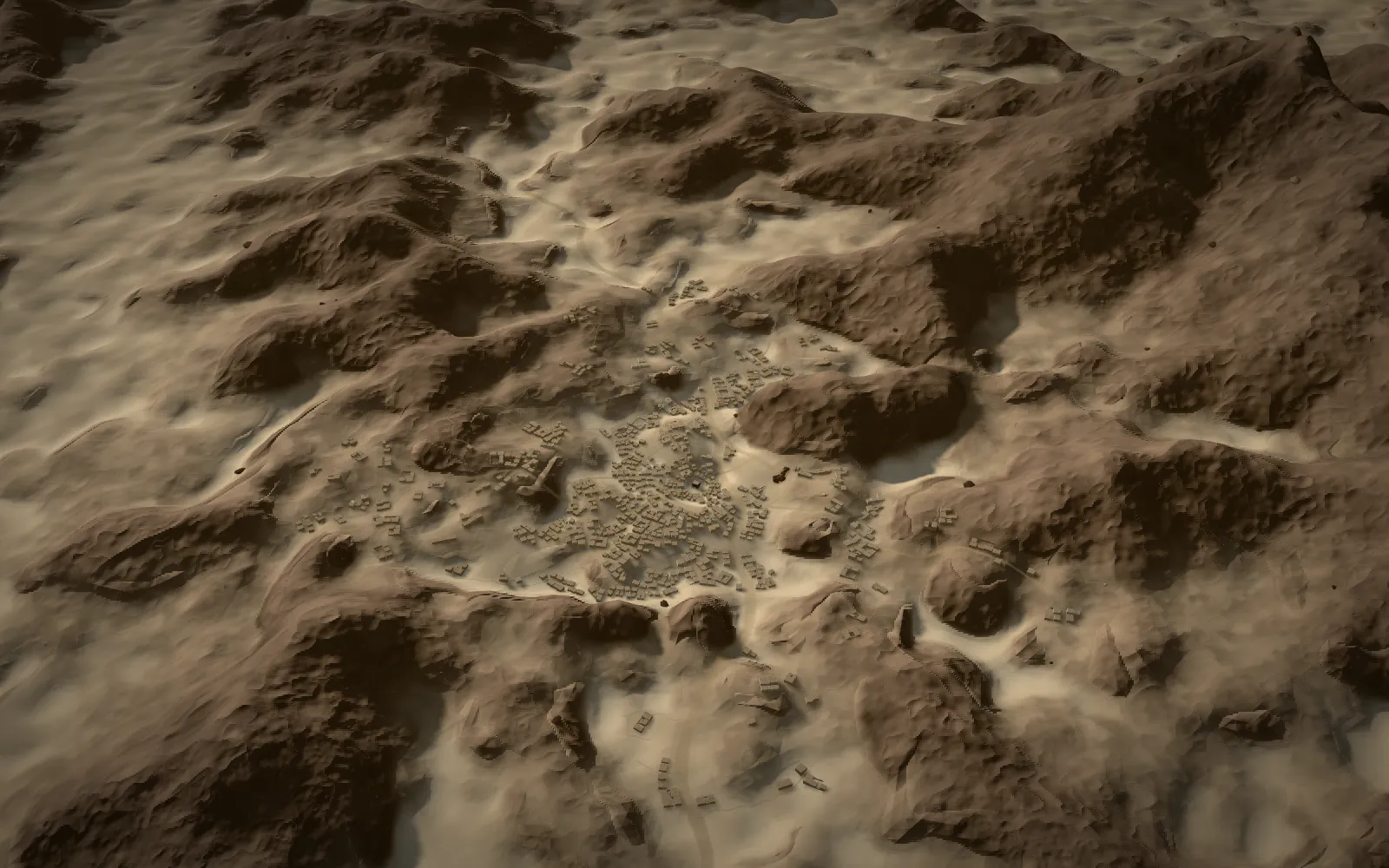
What Makkah looked like at the time of the Prophet ﷺ
The scene covers the years of the first revelation, 610 to 615 CE. In those years the Prophet Muhammad ﷺ lived with Khadijah ﵂ in her house near Marwa, and the early Muslim community met at Dar al-Arqam on the slope of Safa. The Ka'bah stood in a small open space hemmed in by house fronts, and unpaved paths ran along the valleys between the ridges.
The sections below follow the valley outward: from the Ka'bah and Zamzam to Safa and Marwa, the houses of the early community, the ravine quarter of Banu Hashim, and the mountains of Hira and Thawr to the north-east and the south. Each place has its own note on where it is placed, how it is reconstructed and which sources support it, and each one opens in the 3D model.
The Ka'bah and the open sanctuary before Islam
The Ka'bah (often spelled Kaaba) stood within an open space for circumambulation, with houses and the routes of the valley around it. The sanctuary had no enclosure wall until 'Umar ﵁ added one in 638 CE. Zamzam, the well of the sanctuary, lay a few paces from the Ka'bah, and the market place of al-Hazwara lay near the sanctuary.
Ka'bah

The sanctuary at the heart of Makkah. A roofed Ka'bah stood within an open space for circumambulation, with houses and the routes of the valley around it. It rose about 18 cubits (roughly 8.5–9 m, cubit length assumed), on a footprint following the Quraysh foundations that later rebuilds kept. Quraysh raised its single door "so as to admit into it whom they wished and prevent whom they wished" (Sahih al-Bukhari 1584). Before Islam, idols stood in and around the Ka'bah (Sahih al-Bukhari 4287, 1601); they are not modelled.
- Location
- Verified modern mapped site · position: high confidence
- Reconstruction
- Roofed form and plain cloth interpreted. Height about 18 cubits (roughly 8.5–9 m, cubit length assumed); footprint following the Quraysh foundations that later rebuilds kept.
- Uncertain
- Historical fabric and textile treatment are not established by this coordinate. Model orientation and ≈11.9 × 10.2 m footprint follow the mapped modern outline; height ≈9 m assumes 18 cubits of ≈0.47–0.5 m.
Zamzam

The well of the sanctuary, a few paces from the Ka'bah. It was re-dug by 'Abd al-Muttalib, grandfather of the Prophet Muhammad ﷺ, and its water served the pilgrims who came to the Ka'bah.
- Location
- Approximate; placed ≈20 m east of the Ka'bah from the modern layout (assumption) · illustrative label anchor · position: medium confidence
- Reconstruction
- Low stone well-head with a small basin; position, form and basin are interpretive.
- Uncertain
- Ibn Ishaq ﵀ (in the recension of Ibn Hisham ﵀) narrates the re-digging; the exact 7th-century well-head position, form and basin are interpretive.
- Sources
al-Hazwara

Al-Hazwara, a place near the sanctuary. The translator's note to Mishkat al-Masabih 2725 identifies it either as a spot at the wheat-sellers' gate or as the market of Makkah, later incorporated into the mosque when it was enlarged; the model shows the market reading. In the hadith of 'Abdullah ibn 'Adi ibn al-Hamra' ﵁ (al-Tirmidhi 3925, Ibn Majah 3108; Mishkat al-Masabih 2725), the Prophet Muhammad ﷺ stood at al-Hazwara and addressed the city at his departure from Makkah, after the period shown here (622 CE).
- Location
- Open market space south-west of the sanctuary, ≈60–120 m from the Ka'bah; position low confidence · illustrative label anchor
- Reconstruction
- Open market space with shade awnings; position low confidence.
- Uncertain
- The hadith establishes that al-Hazwara existed; the address it records belongs to 622 CE, not to 610–615 CE. Its exact position and extent in 610–615 CE are not established.
Safa and Marwa
Safa and Marwa are two small hills on the eastern side of the sanctuary, linked by an open passage. The model keeps that passage clear of buildings and shade structures; it is not the modern roofed or paved corridor.
Safa

A small rocky rise at the foot of Abu Qubays, southeast of the Ka'bah. From here, the open passage between the hills led north toward Marwa. Around 613, the Prophet ﷺ called the clans of Quraysh from Safa to warn them (Sahih al-Bukhari 4770).
- Location
- Verified modern mapped site; historical profile interpretive · position: high confidence
- Reconstruction
- Ancient hill shape interpreted; modern terrain cannot recover its original volume.
- Uncertain
- Do not infer ancient summit height or full volume from the modern interior.
Marwa

The northern of the two small hills linked by the Sa'i passage. Together with Safa, it helps reveal the changing ground along the sanctuary's eastern side.
- Location
- Verified modern mapped site; historical profile interpretive · position: high confidence
- Reconstruction
- Ancient hill shape interpreted; modern terrain cannot recover its original volume.
- Uncertain
- The reconstructed hill volume is interpretive.
The house of Khadijah ﵂
The Prophet Muhammad ﷺ lived in the home of Khadijah ﵂ near Marwa throughout the years shown in this scene. Its location is attested, while its plot and plan are illustrative. 'Uqba ibn Abi Mu'ayt lived in the same quarter, and Ibn Ishaq ﵀ names him among the neighbours who were hostile to the Prophet ﷺ.
House of Khadijah ﵂

The home of Khadijah ﵂, north-east of the sanctuary near Marwa, on the lane known as Zuqaq al-'Attarin (later Zuqaq al-Hajar). The Prophet Muhammad ﷺ lived here with Khadijah ﵂ throughout the years shown in this scene, 610–615 CE.
- Location
- Relative location near Marwa supported; exact plot unverified · illustrative label anchor · position: medium confidence
- Reconstruction
- Location near Marwa on Zuqaq al-'Attarin is attested; the plot, footprint and courtyard plan are illustrative.
- Uncertain
- Location follows al-Azraqi and al-Fakihi as discussed by Al-Furqan; the scene anchor, footprint and courtyard plan are illustrative.
- Sources
House of 'Uqba ibn Abi Mu'ayt

House of 'Uqba ibn Abi Mu'ayt. Ibn Ishaq ﵀ lists him among the neighbours who were hostile to the Prophet ﷺ. Approximate: within about 30 m of the house of Khadijah ﵂.
- Location
- Approximate; placed within ≈30 m of the house of Khadijah ﵂, whose neighbours he was among; exact plot unknown · illustrative label anchor · position: low confidence
- Reconstruction
- Illustrative stone house and courtyard; original plan unknown.
- Uncertain
- Ibn Ishaq ﵀ (in the recension of Ibn Hisham ﵀) lists him among the neighbours who harmed the Prophet ﷺ; the anchor, footprint and plan are illustrative.
- Sources
Dar al-Arqam and Dar al-Nadwa
Two houses of early Makkah stand on either side of the sanctuary in the model: Dar al-Nadwa, the council house of Quraysh, to the north, its entrance facing the sanctuary, and Dar al-Arqam on the slope of Safa, where the Prophet Muhammad ﷺ met the early Muslim community. Their exact plots are unknown, so both are shown as illustrative stone houses with courtyards.
Dar al-Arqam

A house on the slope of Safa where the Prophet Muhammad ﷺ met the early Muslim community. It places the story of early revelation within the hillside neighbourhoods of Makkah.
- Location
- Safa-slope relationship supported; exact plot unverified · illustrative label anchor · position: medium confidence
- Reconstruction
- Illustrative stone house and courtyard; original plan unknown.
- Uncertain
- Do not label an invented geocoordinate or house plan as established.
- Sources
Dar al-Nadwa

The council house of Quraysh stood north of the Ka'bah, beyond the open sanctuary space. Its entrance faced the sanctuary, linking civic deliberation with the town's religious centre.
- Location
- Relative location supported; exact plot unverified · illustrative label anchor · position: medium confidence
- Reconstruction
- Illustrative stone house and courtyard; original plan unknown.
- Uncertain
- Any chosen exact scene anchor, footprint, size and roof form must be marked illustrative.
Shi'b Abi Talib: the valley of the boycott
The ravine quarter of Banu Hashim, the clan of the Prophet Muhammad ﷺ, is also known as Shi'b Abi Talib. It lay east of the sanctuary below Abu Qubays. The boycott that confined the clan there, c. 616/617 to 619 CE, came after the years this model shows, so the quarter is marked as a broad area and its houses are not rebuilt.
Shi'b Bani Hashim
The ravine quarter of Banu Hashim, the clan of the Prophet Muhammad ﷺ, east of the sanctuary below Abu Qubays. The boycott that confined the clan here, c. 616/617–619 CE, came later than the period shown in this scene.
- Location
- Broad ravine quarter at the foot of Abu Qubays, label anchor at bearing ≈50° and ≈380 m from the Ka'bah; exact extent unverified · position: low confidence
- Reconstruction
- Broad-area label only; the ravine's ancient width and house plots are not reconstructed.
The Cave of Hira on Jabal al-Nour
Hira rises north-east of the settlement, apart from the central town. Its cave is associated with the first revelation to the Prophet Muhammad ﷺ, around 610 CE. The model keeps the mountain and the cave as two distinct places and leaves out the modern paths and visitor infrastructure.
Hira / Jabal al-Nour

Northeast of the settlement rises Hira, now also called Jabal al-Nour. Its cave is associated with the first revelation to the Prophet Muhammad ﷺ, around 610 CE.
- Location
- Verified modern mapped peak · position: high confidence
- Reconstruction
- Reported summit elevation 642 m is a published value, not a measured sample from this model's DEM.
Cave of Hira

Cave on Hira associated with the first revelation to the Prophet Muhammad ﷺ.
- Location
- Verified modern mapped cave entrance · position: high confidence
- Reconstruction
- Keep cave and peak distinct; modern paths and visitor infrastructure are excluded.
Jabal Thawr and the cave of the Hijrah
Thawr stands beyond the southern valleys. It is in the model for its geography: its cave would later shelter the Prophet Muhammad ﷺ and Abu Bakr ﵁ during the Hijrah in 622 CE, after the period shown here.
Jabal Thawr

South of Makkah stands Thawr. Its cave would later shelter the Prophet Muhammad ﷺ and Abu Bakr ﵁ during the Hijrah in 622 CE, after the period shown here.
- Location
- Verified modern mapped peak · position: high confidence
- Reconstruction
- Published heights vary; Saudipedia reports 760 m. The coordinate is a peak, not a cave-entrance survey.
The mountains and valleys around the sanctuary
Makkah lies in connected dry valleys enclosed by rocky ridges. The ranges below are placed from historical topographic plans and modern elevation data; their names locate broad regions, not surveyed ancient summits.
Abu Qubays
Immediate eastern mountain enclosure behind Safa.
- Location
- Eastern relationship established; historic summit geometry unverified · illustrative label anchor · position: medium confidence
- Reconstruction
- Secondary modern reference anchor 21.42278,39.82889 exists, but has not been independently verified as an ancient summit; central terrain is altered.
Qu'ayqi'an
Western and northwestern mountain enclosure of central Makkah.
- Location
- Western/northwestern range established; exact summit unverified · illustrative label anchor · position: low confidence
- Reconstruction
- Historic range name should not be presented as a precisely surveyed individual peak.
Khandama
Ridge system east of the central valley, extending southeast of Abu Qubays.
- Location
- Historic eastern ridge relationship; exact geometry unverified · illustrative label anchor · position: low confidence
- Reconstruction
- Historic-map interpretation; summit height and ancient surface have not been verified.
Jabal Umar
Western/southwestern central hill represented on the historical topographic plans.
- Location
- Historic western hill relationship; exact geometry unverified · illustrative label anchor · position: low confidence
- Reconstruction
- Modern resort development is not a historical contour source; do not use the namesake mountain at 20.36667,40.73333.
Wadi Ibrahim
Connected dry low ground through Makkah, with the northern al-Ma'la approach, southern Misfalah continuation and branching ravines.
- Location
- Central basin established; exact historic channel unverified · illustrative label anchor · position: medium confidence
- Reconstruction
- Any highlighted channel is an interpretation unless it has been derived from, and validated against, a suitable historical surface.
How this reconstruction was made: what is known, what is assumed
The houses, sanctuary clearing and architectural details are reconstructions, not excavated footprints. Unpaved paths and house frontages form an interpretive street network along historically supported valley relationships. Exact routes, widths and plots are not known. The open Safa–Marwa passage is protected from buildings and shade structures; it is not the modern roofed or paved corridor. The sanctuary is a small open space hemmed in by house fronts; it had no enclosure wall until 'Umar ﵁ added one in 638 CE. Dar al-Nadwa is placed north of the sanctuary, and Dar al-Arqam near Safa; their exact plots are unknown. The home of Khadijah ﵂, where the Prophet Muhammad ﷺ lived throughout 610–615 CE, stands near Marwa on Zuqaq al-'Attarin (later Zuqaq al-Hajar); that location is attested, while its plot and plan are illustrative. Zamzam is shown as a low stone well-head about 20 m east of the Ka'bah, a position assumed from the modern layout. The Ka'bah's orientation follows its mapped footprint, and it is shown roofed with a plain, muted textile covering; its colour is illustrative. Its height is about 18 cubits (roughly 8.5–9 m, cubit length assumed), on a footprint following the Quraysh foundations that later rebuilds kept, with the single door that Quraysh raised "so as to admit into it whom they wished and prevent whom they wished" (Sahih al-Bukhari 1584). Before Islam, idols stood in and around the Ka'bah (Sahih al-Bukhari 4287, 1601); they are not modelled. There are no later mosque colonnades, minarets, modern marble courts or human figures.
One model unit equals one metre. Heights are shown exaggerated ×1.5 for legibility; horizontal positions and building dimensions are unchanged, and buildings stay grounded on the exaggerated terrain. Modern mapped anchors identify known sites; range labels locate broad regions rather than certified ancient summits. The DEM under-resolves some peaks; published mountain heights should not be inferred from this surface.