THE HIJAZ · 1 AH
The Hijrah Route, Makkah to Quba, 622 CE
This page follows the Hijrah, the journey of the Prophet ﷺ and Abu Bakr ﵁ from Makkah (Mecca) to Quba on the edge of Madinah (Medina) in September 622 CE, over the real terrain of the Hijaz.
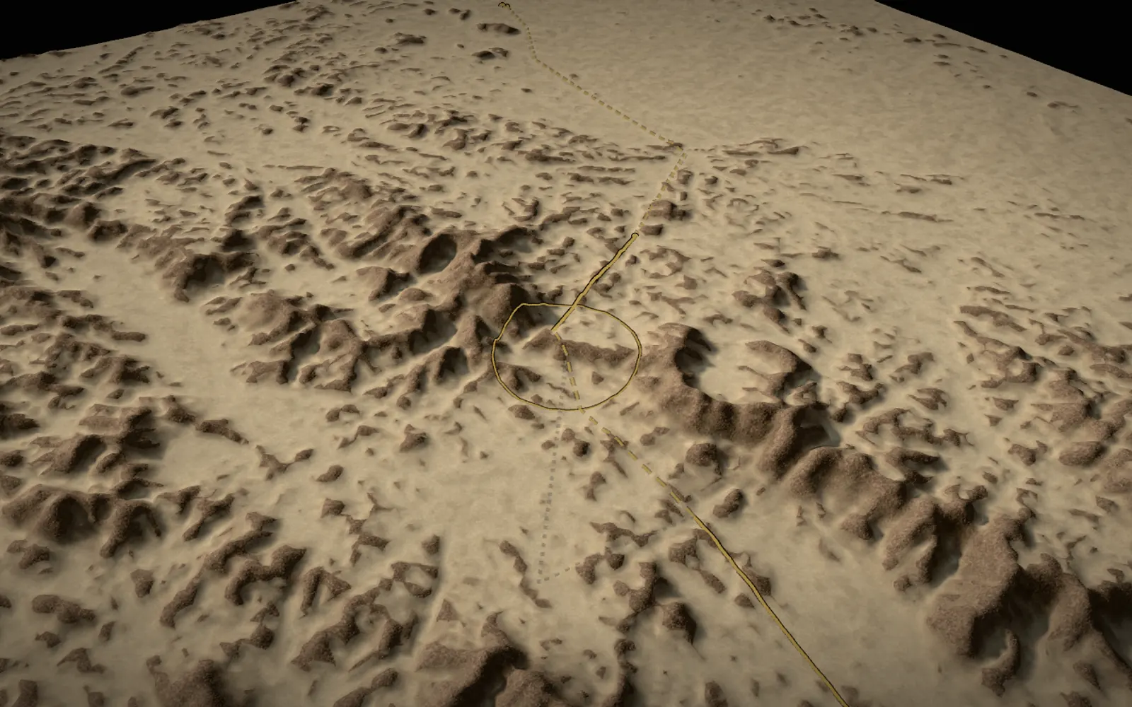
The model draws the route across more than 400 km of mountains, coastal plain and passes: the three nights in the Cave of Thawr, the coast road below 'Usfan, the tents of Umm Ma'bad at Qudayd, the pursuit of Suraqa ibn Malik, the ravines past al-Juhfa, the Rakubah pass and the arrival at Quba. The sources differ on the waypoints, so the line shows what is named in them, what is reconstructed and where other readings run, and every stop below gives its date, its sources and how sure its place is. Each one opens in the 3D model.
Leaving Makkah and the Cave of Thawr
'A'ishah ﵂ relates that the Prophet ﷺ came to her father at noon, an hour at which he never came, and told him that permission to leave had been given; Abu Bakr ﵁ had fed two camels for four months against this day (Sahih al-Bukhari 3905). The two men left Makkah by night and turned south, away from the road to Madinah, to a cave near the top of Mount Thawr. Ibn Hajar ﵀ harmonises the reports into a departure on a Thursday at the end of Safar, with the nights of Friday, Saturday and Sunday spent in the cave (Fath al-Bari 7:278 and 7:287); a report from 'Urwah ﵀ gives two nights, Sahih al-Bukhari three.
The cave is the part of the story that the Qur'an itself recalls (al-Tawbah 9:40), and the part that later tellings embroidered most. The spider and the doves appear in no geometry of the model; their grading is given with the stop below. The mountain in the model is smoothed by the coarse terrain, so its summit reads lower than the 760 m published for it.
The valley of Makkah itself, with Thawr at its southern edge, is on the Makkah in 3D page, which shows the town in the years of the first revelation.
The house of Abu Bakr ﵁ (Makkah)

The Prophet ﷺ came to the house of Abu Bakr ﵁ at noon, an hour at which he never visited, and told him that permission to leave had been given. Asma' bint Abi Bakr ﵂ tied the bag of provisions with a strip torn from her waist-wrap, and from then on she was called 'she of the two belts' (Sahih al-Bukhari 3905). The two men left by night and made for the south, away from the road to Madinah.
- Location
- Central Makkah, on the mapped Ka'bah; the house itself is not located · position: high confidence for the town
- Reconstruction
- The house of Abu Bakr ﵁ has not been located, so the stop stands on the Ka'bah as the anchor of the town. Ibn Hajar ﵀ dates the departure to a Thursday at the end of Safar; that day and its Gregorian equivalent are reconstructions.
- Sources
- Hadith text, sunnah.com ↗
- Mapped site, openstreetmap.org ↗
- Fath al-Bari (Arabic), islamweb.net ↗
- al-Waqidi, via Ibn Hajar, Fath al-Bari 7:278 (a back opening of the house)
The Cave of Thawr

For three nights the Prophet ﷺ and Abu Bakr ﵁ hid in a cave near the top of Mount Thawr, south of Makkah, at the end of a steep climb of some 450 m. 'Abdullah ibn Abi Bakr ﵁ spent each night with them and slipped back into Makkah before dawn with the news of Quraysh, while 'Amir ibn Fuhayrah ﵁ grazed a flock nearby and brought them milk after dark. When the searchers stood above the cave, Abu Bakr ﵁ said that if one of them looked at his feet he would see them, and the Prophet ﷺ answered: 'What do you think of two when Allah is their third?' (Sahih al-Bukhari 3653). The Qur'an recalls the moment: 'Do not grieve, Allah is with us' (al-Tawbah 9:40).
- Location
- The mapped cave entrance, 14 m from the summit of Mount Thawr · position: high confidence (mountain), medium (cave spot)
- Reconstruction
- Later narrations add that a spider spun its web across the entrance and that a pair of doves nested there. Hadith scholars differ on these reports. Ibn Hajar ﵀ and Ibn Kathir ﵀ judged the chain of the spider report in the Musnad of Ahmad acceptable (hasan); al-Albani ﵀ and the editors of the Musnad judged it weak, and the report of the doves is weaker still. What the authentic hadith and the Qur'an record is the protection itself. The model draws neither: the cave has no geometry, and at the scale of the route the mountain is smoothed (its summit, published at 760 m, samples lower in this terrain).
- Sources
- Hadith text, sunnah.com ↗
- Hadith text, sunnah.com ↗
- Hadith text, sunnah.com ↗
- Mapped site, openstreetmap.org ↗
- Grading, islamqa.info ↗
- Grading, islamqa.org ↗
- Qur'an, al-Tawbah 9:40
- Ahmad, al-Musnad 1:348, no. 3251 (the spider report)
- al-Albani, al-Silsilah al-Da'ifah, no. 1128
The guide and the coast road
The guide, a man of Banu al-Dil who 'was on the religion of the disbelievers of Quraysh', brought the two camels to the cave on the morning after the third night, and the four set out, 'Amir ibn Fuhayrah ﵁ with them, while the guide 'took them along the coast road' (Sahih al-Bukhari 3905). Hisham ibn al-Kalbi ﵀ dates the setting out to the night before Monday, the first of Rabi' al-Awwal.
No early source describes the way out of Makkah in detail. Ibn Ishaq ﵀ writes only that the guide took them below Makkah, then along the shore, and across the road below 'Usfan. Al-Biladi ﵀ reads 'the coast road' as the Tihamah plain rather than the waterline and runs the first night inland, west from Thawr and across the Jeddah track with al-Hudaybiyyah on the riders' left; the model draws his line and shows the literal shore route faint beside it. Both meet at the spring of al-Ghawla' below 'Usfan. The next day, when the heat came, Abu Bakr ﵁ spread a skin in the shade of a rock for the Prophet ﷺ to rest (Sahih al-Bukhari 3615); al-Biladi ﵀ places that halt near al-Daff, a spot the hadith does not name.
The guide and the coast road
On the morning after the third night the guide, 'Abdullah ibn Urayqit of Banu al-Dil, brought the two camels to the cave. He still followed the religion of Quraysh, yet they trusted him with the camels and the secret. With 'Amir ibn Fuhayrah ﵁ the party of four took the coast road (Sahih al-Bukhari 3905), and in the reading of al-Biladi ﵀ the guide led them through the Tihamah plain below 'Usfan, crossing the main road only by night.
- Location
- The spring of al-Ghawla' below 'Usfan (mapped); placing the card there is an assumption · position: medium confidence
- Reconstruction
- The sources do not say where the party joined the coast. The line out of Makkah follows the field reconstruction of al-Biladi ﵀, who walked the country; a faint alternative follows 'below Makkah, then along the shore' read literally. The card stands on the spring of al-Ghawla' below 'Usfan, where all three lines meet. The guide's name is also given as 'Abdullah ibn Arqat, in the text of Ibn Hisham ﵀, and spelled Uraiqit.
- Sources
The first day
They rode through the night and the next morning until the midday heat. Abu Bakr ﵁ found the shade of a rock, spread a skin for the Prophet ﷺ to rest, and asked a passing shepherd for milk (Sahih al-Bukhari 3615; Sahih Muslim 2009). The field reconstruction of al-Biladi ﵀ places the day's hiding place in a ravine of Jabal Jamdan near al-Daff, where a tree is still visited, but the hadith does not name the spot.
- Location
- The mapped village of al-Daff; the ravine itself is an assumption · position: medium confidence (village)
- Reconstruction
- Place not named in the sources: the marker follows al-Biladi ﵀ at the village of al-Daff.
Qudayd: Umm Ma'bad and Suraqa ibn Malik
At Qudayd, in the land of Khuza'ah, the travellers stopped at the tents of Umm Ma'bad. Her story, with the weak sheep and the description of the Prophet ﷺ that she gave her husband, is told by al-Hakim ﵀ and al-Tabarani ﵀ and is famous in the books of sirah, though its chains are graded differently, as the stop below explains. Umm Ma'bad and Abu Ma'bad are named here without an honorific, because their acceptance of Islam is reported only later.
Ibn Sa'd ﵀ puts the pursuit of Suraqa ibn Malik on the Tuesday, at Qudayd; al-Biladi ﵀ places it further north, where the route comes down into Wadi Duran. Suraqa rode out for the reward of Quraysh, and turned back with a safe-conduct written on leather after his horse sank into the ground (Sahih al-Bukhari 3906). He is named without an honorific at the pursuit, since he accepted Islam nearly eight years later at al-Ji'ranah, when he brought the document back (Ibn Ishaq, in the translation of Guillaume, p. 226).
The tents of Umm Ma'bad

At Qudayd, the land of Khuza'ah, the travellers stopped at the tents of Umm Ma'bad al-Khuza'iyyah, who in a year of drought had no meat or dates to sell. The Prophet ﷺ asked leave to milk a sheep too weak to go out with the flock, mentioned the Name of Allah ﷻ, and it gave milk enough for everyone, with a full vessel left for her. When Abu Ma'bad came home and asked who had passed, she gave the description of the Prophet ﷺ that the biographies have kept ever since.
- Location
- About 4.5 km north-north-west of the Qudayd hamlet; no mapped site · position: assumption (ring of 5 km)
- Reconstruction
- The report is related by al-Hakim ﵀, al-Tabarani ﵀ and others. Al-Hakim ﵀ called its chain sound and al-Dhahabi ﵀ agreed; al-Haythami ﵀ noted weak narrators; Ibn Kathir ﵀ said its many chains strengthen one another, and al-Albani ﵀ judged it weak in itself but possibly raised to hasan by its chains. It is famous in the books of sirah. Her acceptance of Islam is reported only as a later event. The exact place is not known: the ring of 5 km marks the northern edge of Qudayd, where al-Biladi ﵀ was shown the spot by a local elder.
- Sources
- Grading (Arabic), islamweb.net ↗
- Grading (Arabic), islamweb.net ↗
- Mapped site, openstreetmap.org ↗
- al-Hakim, al-Mustadrak 4274
- al-Tabarani, al-Mu'jam al-Kabir
- Ibn Kathir, al-Bidayah wa al-Nihayah
The pursuit of Suraqa ibn Malik

Quraysh had offered a hundred camels for each of the two men. In the assembly of Banu Mudlij near Qudayd a man said he had seen riders on the coast, and Suraqa ibn Malik, hoping for the reward, played the report down and rode out alone. Close enough to hear the Prophet ﷺ reciting, his horse stumbled and threw him, and at last its forelegs sank into the ground up to the knees; he called out for safety. At his request 'Amir ibn Fuhayrah ﵁ wrote him a safe-conduct on a piece of leather, and Suraqa turned back, sending other pursuers away (Sahih al-Bukhari 3906, 3615). He kept the document for nearly eight years and brought it to the Prophet ﷺ at al-Ji'ranah after Hunayn, in Dhu al-Qa'dah 8 AH (early 630 CE), where he accepted Islam. From then on he is counted among the Companions: Suraqa ibn Malik ﵁.
- Location
- Place uncertain: Qudayd to lower Wadi Duran; the marker follows al-Biladi ﵀ at Kulayyah · position: low confidence
- Reconstruction
- The exact place is not known. Ibn Sa'd ﵀ and al-Tabarani ﵀ put the encounter at Qudayd itself; al-Biladi ﵀ puts it in lower Wadi Duran near Kulayyah, 20.8 km further north. The ellipse joins the two; its width is an assumption of the drawing.
- Sources
- Hadith text, sunnah.com ↗
- Hadith text, sunnah.com ↗
- Hadith text, sunnah.com ↗
- Hadith text, sunnah.com ↗
- Mapped site, openstreetmap.org ↗
- Mapped site, openstreetmap.org ↗
- Ibn Ishaq (trans. Guillaume), archive.org ↗
- Ibn Sa'd, via Ibn Hajar, Fath al-Bari 7:286 (Tuesday, at Qudayd)
Past al-Juhfa and through the ravines
North of Qudayd the guide kept east of al-Juhfa, within sight of it, and turned inland at al-Kharrar, away from the coast and the usual road. From here Ibn Ishaq ﵀ names valley after valley: Liqf and its waterhole, the ravines of Mijaj and Dhu al-Ghadwayn, Dhu Kashr, al-Ajrad (which al-Biladi ﵀ reads as Ujayrid), and Ta'hin. Al-Biladi ﵀ found most of these names still used for side ravines between Wadi al-Far' and al-Qaha, and judged the choice deliberate: the shortest line that stayed out of sight and used hidden waters.
Past al-Juhfa
The guide kept east of al-Juhfa, later the miqat of the people of al-Sham, then turned inland at al-Kharrar and climbed away from the coast toward the valleys of al-Far'. Ibn Ishaq ﵀ names al-Kharrar on the way; al-Biladi ﵀ identifies it with the wadi of al-Juhfa and Ghadir Khumm, east of Rabigh.
- Location
- East of the mapped Miqat al-Juhfa, from the description of al-Biladi ﵀ · position: assumption (ring of 5.5 km)
- Reconstruction
- Al-Biladi ﵀ says the party passed al-Juhfa 'on its east, within sight of it'. The spot is placed 5.5 km east of the mapped miqat, and the ring of the same radius reaches al-Juhfa itself. Others put al-Kharrar on the coast, at Sharm al-Kharrar, 35.8 km away.
Liqf and the ravines
Here Ibn Ishaq ﵀ names a string of small valleys one after another: Liqf, the ravines of Mijaj and Dhu al-Ghadwayn, Dhu Kashr, al-Ajrad, Ta'hin. Al-Biladi ﵀ found most of the names still in use for side ravines between Wadi al-Far' and al-Qaha: a route chosen for its hidden waters, not for its ease.
- Location
- The mapped mouth of Wadi Liqf at Wadi al-Far' · position: medium confidence
- Reconstruction
- The party crossed Wadi al-Far' at the mouth of Liqf, in the words of al-Biladi ﵀, and that mouth is mapped. The ravines after it are named in the sources, but their positions are not known, so the line between Liqf and Ta'hin is reconstructed.
The Rakubah pass and the valley of Ri'm
From al-Qaha the route climbs to the hardest stretch of the journey. Ibn Ishaq ﵀ takes the party down to al-'Arj, where a mount lagged and Aws ibn Hujr of Aslam lent them a camel, and then over Thaniyyat al-'A'ir, to the right of Rakubah, into the valley of Ri'm. Al-Biladi ﵀ thought the passage through al-'Arj a pointless detour, and ran the line straight from al-Hafat to the pass; drawn over the same waypoints, the detour adds about 13 km. The model draws his line and shows the al-'Arj reading as the faint alternative; the switch in the scene settings draws either as the main line.
The head of Wadi Ri'm, at about 1,100 m, is the highest ground of the whole journey in the terrain data. From there the valley runs down to al-'Aqiq, and the route turns north past the slope of Jabal 'Ayr toward the lava plain south of Madinah.
The Rakubah pass

From al-Qaha the travellers crossed the high ground by Thaniyyat al-'A'ir, to the right of Rakubah, a pass the Arabs counted among the hardest in the Hijaz, and came down into the valley of Ri'm. Ibn Ishaq ﵀ takes them first down to al-'Arj, where one of the mounts lagged and a man of Aslam, Aws ibn Hujr, lent a camel; al-Biladi ﵀, who walked the ground, thought the detour to al-'Arj unlikely. Both lines are shown.
- Location
- Between Wadi al-Halqa and the head of Wadi Ri'm (both mapped); the spot is unknown · position: assumption (ring of 5.3 km)
- Reconstruction
- The name of the pass is agreed; the spot is not known. The marker stands in the gap between Wadi al-Halqa and the head of Wadi Ri'm, toward Warqan, and the ring of 5.3 km reaches both ends of that gap. Around here the route climbs to its highest ground, about 1,100 m at the head of Ri'm.
Ri'm and the approach
Down the valley of Ri'm the party reached the basin of al-'Aqiq and turned north toward the lava plains south of Madinah, where the Muslims of the town went out every morning to watch the road.
- Location
- The junction of the mapped channels of Wadi Ri'm · position: high confidence
- Reconstruction
- The valley of Ri'm is mapped; the line beyond it, down to al-'Aqiq and past the slope of Jabal 'Ayr, follows al-Biladi ﵀ alone.
Arrival at Quba and the first Friday
The Muslims of Madinah had gone out every morning to wait for the riders and gone home in the heat. The Prophet ﷺ arrived among Banu 'Amr ibn 'Awf at Quba on a Monday (Sahih al-Bukhari 3906), stayed there some nights, fourteen in the report of Anas ﵁, and founded its mosque. On a Friday he left Quba and prayed the first Friday prayer in the bed of Wadi Ranuna, among Banu Salim ibn 'Awf, before riding on into Madinah (Ibn Ishaq, in the translation of Guillaume, p. 228).
Quba, Ranuna and the oasis they belong to are on the Madinah in 3D page, which begins where this route ends.
Arrival at Quba

The Muslims of Madinah had gone out every morning to the lava plain and gone home when the shade was gone; it was a Jewish man on a lookout who first saw the riders and called out that the one they awaited had come. The Prophet ﷺ turned right into Banu 'Amr ibn 'Awf at Quba on a Monday, and those of the Ansar who had never seen the Prophet ﷺ greeted Abu Bakr ﵁ first, until the sun fell on the Prophet ﷺ and Abu Bakr ﵁ shaded him with his cloak (Sahih al-Bukhari 3906). He stayed there some nights, fourteen in the report of Anas ﵁, and founded the mosque of Quba; 'Ali ﵁ joined him there from Makkah.
- Location
- Quba, the mapped quarter of Banu 'Amr ibn 'Awf · position: high confidence
- Reconstruction
- The same point as Quba in the Madinah model. The Monday is in Sahih al-Bukhari; the day of the month is given as the 1st, 2nd, 7th, 8th, 12th, 13th or the middle of the month, and the length of the stay as three, four, ten-odd, fourteen or twenty-two nights. His host was Kulthum ibn al-Hidm ﵁ in the account of Ibn Ishaq ﵀; others say Sa'd ibn Khaythamah ﵁.
The first Friday
Leaving Quba on a Friday, the Prophet ﷺ prayed the first Friday prayer among Banu Salim ibn 'Awf in the bed of Wadi Ranuna, then rode on into Madinah, as Ibn Ishaq ﵀ reports.
- Location
- The mapped bed of Wadi Ranuna · position: medium confidence
- Reconstruction
- The same point as the first Friday prayer in the Madinah model, 708 m from Quba. Ibn al-Kalbi ﵀ dates the entry to the 12th of Rabi' al-Awwal; Ibn Hajar ﵀ gives the 22nd, counting fourteen nights in the report of Anas ﵁, a figure left unverified here, since fourteen nights after a Monday 8th fall on a Monday, not a Friday.
Dating the journey
The sources agree on the order of the days more than on their dates. The arrival was on a Monday; Ibn Hajar ﵀ says this is what is relied on, and that whoever said Friday is irregular. For the day of the month he lists the 1st, the 2nd, the 7th, the 8th, the 12th, the 13th and the middle of Rabi' al-Awwal (Fath al-Bari 7:287). The 12th is the date in the text of Ibn Hisham ﵀; the 8th is the one Ibn Hajar ﵀ derives, and the one that falls on a Monday on the tabular calendar.
The Gregorian dates on this page are reconstructions. The months before 10 AH were not yet fixed to the tabular scheme, and the old practice of intercalation (nasi'), not abolished until 10 AH, could shift any equivalent by days or more, so the page gives only 'September 622 CE'. The dated line of each stop says when a day is reconstructed.
How this route was reconstructed: what is known, what is assumed
Every waypoint of the line has a coordinate from OpenStreetMap or, where nothing is mapped, a position derived from a description in the sources, with its reasoning recorded. Each is labelled high, medium or low confidence, or assumption. Where the sources name a place and it is mapped with medium or high confidence the line is solid; between such places it is dashed. Assumed spots carry a ring instead of a marker, sized to what the description allows. The line joins its waypoints in straight stretches over the terrain; it has not yet been snapped to the valley floors, so it cuts across bends and ridges, and its length, about 410 km, is a lower bound. The official walking trail on the route, launched in 2025, is published as 470 km.
The terrain is modern public elevation data resampled every 450 m, exaggerated ×2 for legibility. At that scale the cave, the tents and the camp sites have no geometry, and no person is ever depicted. Nothing on the ground is later than 622 except the terrain itself, and the modern roads and towns are not drawn.